Chicago L.org is a tremendous resource for all things CTA. I cannot speak highly enough of the page. One thing I love on the page is information about various plans for expansion of the system. I would love to drill through all of them, but I am thinking about what would be different had the Kelker Plan of 1923 been implemented. This was a plan proposed by a full time engineer for the City Council Committee on Local Transportation, so this plan had more credibility than some of the "civic group" plans that periodically were introduced.
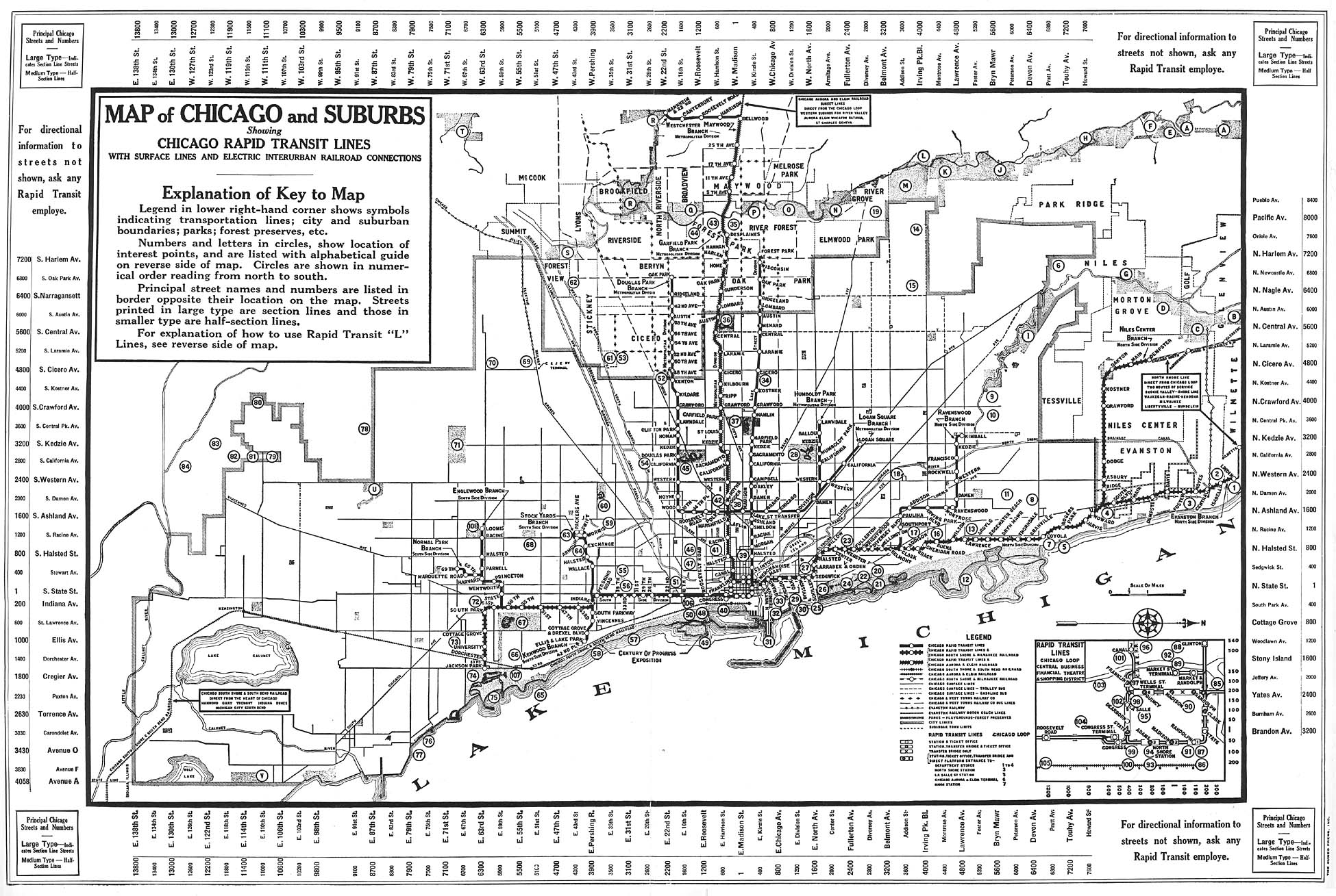
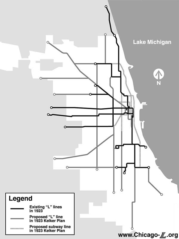
One interesting element of the plan was that it added or expanded 15 rail lines. Some were subways, some were elevated. This is really interesting because at the time Chicago had the largest street car network in the world. At the time the system looked like this, and with some variations the Brown Line, Red Line, Purple Line, the Blue Line up to Logan Square, as well as the Blue Line routed west in an alley between Congress and Van Buren (prior to the Eisenhower's construction), Green Line, and three south side shuttles to the Stockyards, Kenwood, and Normal Park all existed.There was also a Humboldt Park Line that went from Damen/North to Humboldt Park along an alley parallel to North Avenue. Except for Orange Line and the extension of the Blue Line to O'Hare, the system was more extensive than it is today. After dozens of efforts to represent this plan on my own map, look at this map from Chicago-L.org to get an idea of the proposed network.
North/South Lines
There were several proposed, entirely new north/south lines. They include trains on Michigan Avenue, State Street, Halsted, Ashland, California, and Kedzie. There were also proposed north/south extensions. The Michigan Avenue train was proposed to connect the north side trains at Sedgwick/North Avenue (the current Brown Line Sedgwick stop) with the Green Line at Cottage Grove/63rd. The entire train was planned as a subway, so the exact route near the ends probably would not have needed to follow the streets. This line is actually not terribly far from the current Red Line, which follows the Dan Ryan, instead of Cottage Grove, and Michigan Avenue instead of State Street.
State Street, however, as not to be denied. A subway line was proposed to go from State Street/18th to connect with the Brown Line at Wilson/Ravenswood. This, of course, means that in the Loop there would be subways one block apart. One would go north to Sedgwick/North (connecting with trains going north to Howard or Kimball), the other to Wilson/Ravenswood (connecting closer to Kimball on the Brown Line). Heading south they would go to State/18th (connecting with the Green Line there) or Cottage Grove/63rd, connecting with . . . the Green Line). Frankly, one of these two lines seems pretty redundant. I would probably choose this one to skip, since it seems to go from nowhere, past other train lines, no nowhere.
The Halsted train would go from Halsted/North to Halsted/87th. This actually ends up being pretty close to the current Red Line on the south side. On the north side the train cuts straight through Goose Island and points south. It is possible that people from Little Italy, Greektown, and neighborhoods further south could have more conveniently commuted to factory jobs in the Clybourn Corridor had this line been built. The line was to be a combination subway and elevated. It should be noted that 87th Street is further south than any train goes today. Under this plan trains at Kedzie (87th) and Calumet (127th) would have gone as far or further south.
The Ashland line was proposed to go from Roscoe/Ashland to Ashland/63rd. The southern terminus would have been at the Stockyards, which were still in full operation in 1923. Roscoe/Ashland is near the Paulina stop of the Brown Line today. Historically the Lincoln/Belmont/Ashland area was a major shopping district and Riverview amusement park was down a streetcar line at Roscoe/Western. This proposed line actually seemed to go to and from some pretty useful places. It is likely that it would have intersected with the Stockyard Line, the west side Blue (Congress) Line, the west side Green (Lake Street) Line, and the Brown Line. The line would have been elevated all the way down Ashland, essentially turning Ashland into what Lake Street, Van Buren, et al. are today.
The Kedzie line was proposed to go from Kedzie/Leland to Kedzie/87th. On the north it would have intersected with the Kedzie stop of the Brown Line. Evergreen Cemetery is at Kedzie/87th. This line would have gone through the middle of Marquette Park, and would have intersected with the Humboldt Park branch of the Blue Line. The line as proposed was to be elevated, which is interesting, since the Kedzie stop on the Brown line is *not* elevated. Although it will be discussed below, Kedzie is also the closest major street to a planned extension going from the Brown Line north along California to Howard, but it is not clear how a trip that started at 87th/Kedzie would have gotten to California/Howard. Why is an even better question.
These lines also appear to be somewhat haphazard, since the distance between the Halsted and Ashland lines would be a mile (with other lines between them in some places), while the distance between Ashland and Kedzie is two miles, with fewer lines between them. In their favor, access to Humboldt Park, Marquette Park, Garfield Park, and Douglas Park would have been expanded by these lines.
It should also be noted that two miles west of Kedzie is Cicero, which seems like a very sensible future expansion, although Cicero mostly runs through the Bungalow Belt, with its lower population densities. Of course, by 1932 Municipal Airport (known as Midway after . . . the Battle of Midway) would open west of Cicero from 55th to 63rd. Without realizing it, this plan actually would have had three lines terminating very near the future Midway Airport. Remember that O'Hare was still 30 years in the future.
The north/south extensions are mostly on the south side. Of course, the south side is bigger and appears to have been more populated as of 1920, so this makes a certain amount of sense. On the north side an elevated train was proposed to go from California/Leland (between the Francisco and Rockwell stops on the Brown Line, but really basically in the river . . .) north along California, past Swedish Covenant Hospital, to the city limits at Howard. This would stop just south of the Skokie Valley train which would later become the Yellow Line. Since this line connects to an existing line where there is no station, and heads north to . . . nowhere, this seems like one of the least advisable lines on the route.
On the south side, an elevated line was proposed from Calumet/63rd (near the King Drive stop on the Green Line) down Calumet to approximately 127th. I guess this would have extended the transit system to the Pullman area, and well as past what would be the future Chicago State University. This line would have been pretty close to the current Red Line from 69th to its terminus at 95th, perhaps proving that the Red Line would have been built one way or another. Chicago still struggles with proposals to extend the train south of 95th.
Interestingly the plan also proposed an elevated line to go from the end of the Jackson Park leg of the Green Line (which now ends at Cottage Grove) south down Cottage Grove and South Chicago to approximately 87th Street. I am not a southeast sider, but I think this route would have created access to some of the steel mills that were in that area. Currently the only mass transit rail service in this area is provided by Metra Electric Line.
I think I will save the lateral additions for a separate post. However, the proposed line to South Chicago/87th points to another issue with this proposal. It does not account for any of the heavy rail lines that already served areas of the city. In fact, essentially all of the current Metra lines were present in the city, and in most cases had more frequent stops in the city. Thus, the lakefront on the south side was already well served by the interurban to South Bend. The same was true of the north lake front. Also, as mentioned above, the plan did not account at all for the streetcar system. To this extent the 1923 line looks like a a classic CTA power grab, rather than an integrated plan for transit in the region.
No comments:
Post a Comment